In the War of 1812 (1812-1815) the United States declared war on England because of trade restrictions, impressment, and British support for Indian attacks. They signed the Treaty of Ghent on December 24, 1814 after reaching a stalemate.
Fincastle County, Virginia was created in 1772 from Botetourt County and abolished in 1776. It was divided into Montgomery, Washington and Kentucky Counties.
There were two Beaver Creeks in early Washington County, Virginia. One (also called Shallow Creek) flowed through Bristol and emptied into the South Fork of the Holston River in Tennessee. The other was a south branch of the North Fork of the Holston River in current Smyth County.
Lewis (Louis) Pitts was born about 1745.
He married Mary Head. Mary was the daughter of Anthony and Mary Head. They married and settled in Washington County, Virginia.
In 1777, Lewis settled on 400 acres at the head of Steel's Creek. The property was near Anthony and Mary Head’s property.
In 1777, Lewis signed the 1777 petition of men living on the north Holston River complaining about the division of Fincastle County. They felt the line was not equitable and the court house was too far away.
At some time, Nicholas Hensley and Lewis Pitts sold land to Jacob Goodman on the waters of Steels Creek branch of Beaver.
On August 16, 1781, Lewis Pitts had 400 acres surveyed on Steels Creek
On June 4, 1782, Lewis Pitts had 300 acres surveyed on Steels Creek.
In 1782 Lewis was on the Washington County tax list. He had 1 tithe, 11 cattle, and 11 horses in Captain James Fulkerson's precinct. That year he was paid 2£ 2 shillings for 7 pounds of powder.
Lewis remained on the tax Washington tax list from 1788 to 1795. The 1790 census was lost during the war of 1812.
In 1796 he had 92 acres on the waters of Beaver Creek.
Lewis was on the 1806 tax list in Washington County.
At the time of the 1810 census, the household was in Washington County, Virginia. The household consisted of
a man and a woman over 45
a young man and woman between 16 and 25
2 boys and a girl under 10.
In the Washington County, Virginia, Deed Book 5 1811-1814 there is an indenture from John and Milly Ringley to Lewis Pitts.
In 1815 Lewis was in the Directory of Virginia Landowners & Gazeteer.
In 1820 the Lewis Pitts household in Washington County, Virginia consisted of
a man and a woman over 45
2 boys under 10
an enslaved young man between 14 and 25
Lewis made his will in 1820 and it was proved in 1825. His wife and son-in law, James Sprouls were the executors of his estate.
Washington County, Virginia was formed from Fincastle County in 1777. It originally contained Sullivan County, Tennessee.
The Battle of Kings Mountain was a decisive battle of the American Revoluton. It took place on October 7, 1780, nine miles south of the present-day town of Kings Mountain, North Carolina. The Patriot militia defeated the Loyalist militia commanded by British Major Patrick Ferguson.
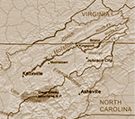
The Holston River flows from Kingsport to Knoxville.
map by Kmusser
Page 392 - James Parbery
1000 ac - treasury warrant #7634 - on Steels Creek, a branch of Beaver Creek, the waters of Holstein [Holsten River
corner to Thomas Elliots land
line of Robert Hensley's land
corner to Alexander McDonald's land
crossing Steels Creek
in forks of a creek corner to Lewis Pitt's land
corner to Nathaniel Cornet's land
on Walkers Mountain
corner to James Hensley's land
in a gap of Walkers Mountain -
March 9, 1791
from Washington County, VA Survey Records Abstracts 1781-1797, submitted to the USGenWeb archives by Rhonda Robertson
Page 453 Lewis Pitts
42 ac
treasury warrant #20702
dated November 11, 1783
on the waters of Beaver Creek, a north branch of Holstein [Holston] River
corner to his survey of settlement right
corner to Parberry's land
crossing the waggon road
near James Sproul's line
May 19, 1796
Lewis Pitts...400 ac...on the head of Steels Creek, includes improvements, actual settlement made in 1777...August 16, 1781.
Lewis Pitts
340 ac
Commissioners Certificate
on a branch of Steels creek, waters of Beaver Creek...
Beginning on the south side of a branch
on the south side of Walkers Mountain
June 4, 1782
from Washington County, Virginia Surveys, Page 471
Richard Moor
166 ac
treasury warrant #4413 dated
March 29, 1780
on the waters of Abrams Creek, a south branch of the north fork of Holstein River
corner to Lewis Pitts land and on a spur of Walkers Mountain
corner to Bayleys survey - crossing a branch of Abram's creek
corner to Smiths survey by an old rotten cabbin a former claim of Poll Cornets
May 18, 1795
When a mark is used for a signature, the person was probably illiterate, but may not have been able to sign because of age or infirmity.
Washington County, Virginia
In the name of God Amen, I Lewis Pitts of the County of Washington and State
of Virginia being weak of body but of perfect sound mind and memory thanks be
to God for his mercies, do make and ordain this to be my last Will and
Testament in manner and form following,
First I order and direct that all my
just debts be paid and my body decently burried
then I give & bequeath to my
loving wife, Mary Pitts the land and premises whereon I now live and dwell
during her natural life and widowhood also all my household and kitchen
furniture, sheep, cattle hog and horses farming utensils also my negro man
Ambris
also it is my Will and desire that my Executor shall make unto my son
Elijah and Elisha Pitts a clear and indisputable right and title to the lands
I have already laid off for them which they now have in possession and at my
said wife's decease the said land and premises with all the moveable property
to be sold and equally divided amongst my children
& lastly I do hereby
appoint James Sproles Executor and my wife Executrix to this my last will and
Testament
The Great Wagon Road was the most important Colonial American route for settlers of the mountainous backcountry. It went from Philadelphia to the Shenandoah Valley of Virginia. One fork went to the Tennessee Valley and Knoxville and the other to the Piedmont Region of North Carolina.